

10 Bucket List Hikes In The US To Do In 2023
This page may contain affiliate links. As an Amazon and Rewardstyle affiliate, we may earn a small commission for any purchases made through these links. Click here for the disclosure statement.
The advent of the new year often brings to many people a renewed determination to spend more time outdoors, explore America’s amazing national parks, and travel in an outdoors capacity. From sea to shining sea, the US has such a wide variety of terrain to discover, and hiking scenic trails is the unparalleled way to experience the natural beauty of the outdoors.
Best Hikes in the US to Do in 2023
If you are looking for inspiration for a future hiking trip, look no further! We have accumulated ten of the most highly-rated, bucket list-worthy hiking trails in the United States.
The Narrows
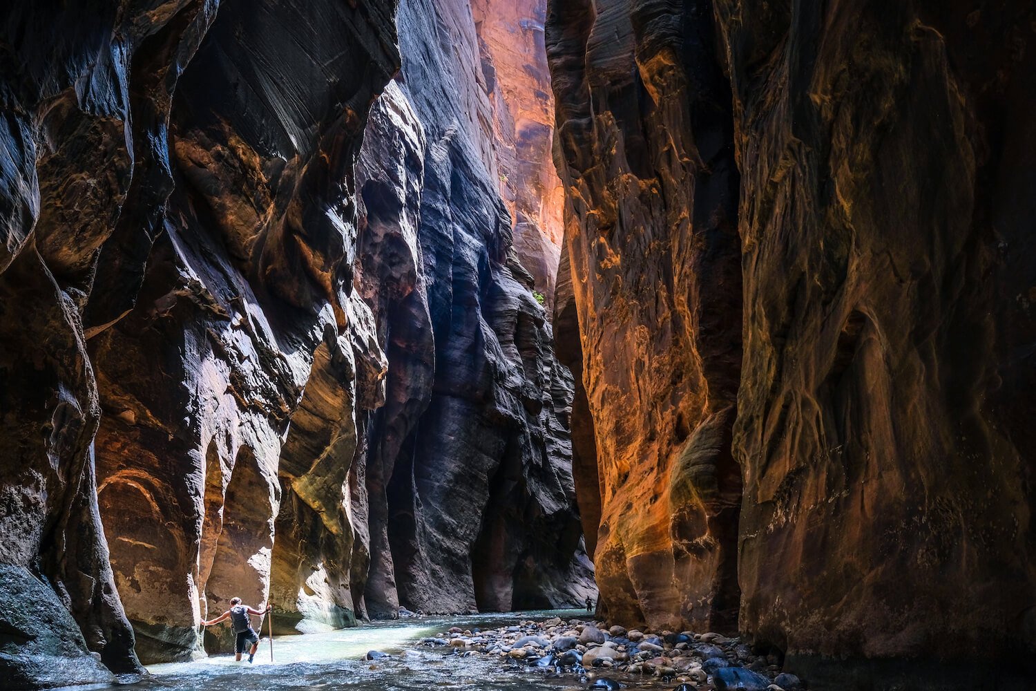
Photo credit: The World Travel Guy
Location: Zion National Park, Utah
Difficulty level: Advanced
Length of hike: 16 miles
Average time to complete: 10 to 13 hours
Elevation Gain: 334 feet
Why it made this list: This famous trail offers such a unique hiking—more like canyoneering—experience. Imagine yourself in a gorge, following a flowing riverbed for miles, enclosed by towering red rock walls a thousand feet high. The Narrows is incredibly memorable because it follows the narrowest part of Zion Canyon, up the beautiful Virgin River. The width of the canyon varies up to 30 feet wide and, depending on the time of year, hikers will at some points be wading in water up to their chest! (Most often, however, it is ankle-deep.) As you can imagine, this hike is considered treacherous as footing can be tricky and slippery due to the river and, in the winter, conditions become more treacherous, as flash floods are possible.
Things to Note: You are able to camp along the way. A permit is needed to hike.
Kalalau Trail

Location: Haena State Park, Kauai, Hawai’i
Difficulty level: Advanced
Length of hike: 22 miles
Average time to complete: 15-17 hours
Elevation Gain: 800 feet
Why it made this list: This scenic trail will make the top of nearly any “best hike” list based out of the United States. Hawaiian landscape is so wildly different from any other state, as the tropical terrain and lush backdrop immediately sets this trail apart. The Kalalau Trail is famous for its aggressive, tropical trail leading hikers along the heavenly island coastline to the immense and awe-worthy Nāpali Coast, all the while winding through lush tropical forests and around steep, treacherous cliffs. It is a tough incline and can be very muddy, as it rains often on Kauai. While possible for very fit and active hikers to complete in a day’s journey out-and-back (without all the camping gear most hikers here will have), nearly all hikers treat this as an overnight trip, and camp down at the destination beach for one or several nights.
Specific sights to see while hiking:
Mile 2: Hanakapiai Beachi
MIle 4: Hanakapiai Waterfall.
Mile 8: Kalalau Beach along the Nāpali Coast
Things to note: This hike is best treated as a backpacking trip. All hikers and campers must secure a permit beforehand and the length of stay cannot exceed 5 nights.
Read more: The Ultimate Kauai Travel Guide
Charles Bunion

Location: Smoky Mountains National Park, North Carolina
Difficulty level: Moderate
Length of hike: 8.1 miles
Average time to complete: 4 hours
Elevation Gain: 1886 feet
Why it made this list: Hiking a length of the famed 2,190-mile Appalachian Trail is very bucket list-worthy. Charles Bunion is one of the most popular hikes of the Smokies, due to its generous, spectacular views and exciting trail climb. The climb is steep and aggressive for the first few miles and takes you through gorgeous, wooded forests. The summit is a wonderful, expansive view of the Smoky Mountains, so beautiful that it will have you wondering if you can finagle more of the Appalachian Trail into your schedule. There is a rocky outcrop that serves as the perfect panoramic viewpoint of the romantic, rolling mountains beyond.
Things to Note: If you would like to make it a backpacking trip, there is a backcountry shelter near the top of the summit. No pets allowed.
Mount Katahdin

Location: Baxter State Park, Maine
Difficulty level: Advanced
Length of hike: 10.9 miles
Average time to complete: 8-12 hours
Elevation Gain: Approximately 4000 feet
Why it made this list: Mount Katahdin is an incredibly popular destination hike, offering excellent panoramas and an exciting hiking challenge. It is the formal end of the Appalachian Trail, so you may meet hikers who have journeyed for 5 or 6 months to stand at the summit! The peak stands at 5,267 feet, the highest point in the state of Maine. There are several trails leading to the summit, differing in length and difficulty, with the Saddle Trail recommended for beginners. Because of the intense 4000 foot elevation gain and steep drop-offs, this hike is rated as strenuous and dangerous. It is best to get your fitness level up for this hiking challenge, as it will require your A-game!
Things to note: Parking spots are limited and can be reserved ahead of time. It is popular to camp at the base of the mountain the night before and get an early start in the morning! If you go the Knife’s Edge Route, please note that it is recommended to go only one way, not out-and-back this particular trail, as it adds a great amount of time and hazard to the trip.
Bright Angel Trail

Location: Grand Canyon National Park, Arizona
Difficulty level: Advanced
Length of hike: 15.3 miles
Average time to complete: 12 - 15 hours
Elevation Gain: 4,460 feet
Why it made this list: A bucket list hiking trail, if there has ever been one. The Grand Canyon is among the Seven Natural Wonders of the World for good reason, and the Bright Angel trail is here to show you why. Bright Angel Trail is the most popular of trails in the national park, but crowds die down after a few miles, particularly after Indian Gardens campgrounds. It takes you down the sheer, world-famous cliffs of the canyon, with out-of-this-world panoramic views at every switchback turn. Remember to watch your footing, as your eyes will want to be glued to the majesty before you! The bottom is announced by your arrival at the Colorado River and the campsite at Phantom Ranch. While possible to make a day hike out of this—if you are an extremely experienced and fit hiker—it is really not recommended, mostly due to the heat and extreme incline. Going down is tiring in itself, and the hard part does not truly start until you turn around and look back up at the 4,460 foot ascent awaiting you (which can take up to double the time as the descent).
Thing to Note: It is popular to descend the South Kaibab trail to the foot of the Canyon, and then return via Bright Angel, just to vary your scenery and trail experience. Heat is a major risk factor here; bring water and become prepared. It is really recommended to camp overnight at the bottom, which will require advance reservation (sometimes months in advance), as opposed to attempting this rim-to-rim in one day.
Half Dome Trail

Location: Yosemite National Park, California
Difficulty level: Advanced
Length of hike: 15-17 miles
Average time to complete: 10 - 12 hours
Elevation Gain: 4,800 feet
Why it made this list: This is one of the most quintessential hikes of California and Yosemite National Park. Claimed at one point to be “inaccessible,” thousands now labor up its exciting, panoramic trail way to a summit 8,839 feet above sea level. This amazing day hike is especially memorable for the last 400 foot ascent to the summit; the combined smooth and steep stone incline necessitates the use of cables, and hikers are grateful for a cable line to grip.
Thing to Note: Rangers rescue hundreds of hikers every summer who bite off more than they can chew, so please be aware of your fitness level when taking on this long, arduous hiking adventure! Many recommend wearing gloves for the cable portion of the hike.
Harding Icefield Trail

Location: Kenai Fjords National Park, Alaska
Difficulty level: Advanced
Length of hike: 8.2 miles
Average time to complete: 6 - 8 hours
Elevation Gain: 3,360 feet (about 1,000 feet every mile)
Why it made this list: This epic trail will give you a proper introduction to the wild, isolated natural beauty of Alaska’s landscape. The trail begins on the valley floor through forests, up a strenuous incline, past tree line, to spectacular vistas of glaciers and ice fields. Standing at 3500 feet, you’ll be taken back in time, looking over the expanse of the U.S.’ largest ice field. The hike is rated as advanced because of its aggressive incline, icy and snowy conditions, and slippery, rocky trail. Hikers are rewarded with epic views and close proximity to glaciers.
Specific sights to see while hiking: Two popular scenic viewpoints are Marmot Meadows at the 1.4 mile mark and Top of the Cliff at the 2.4 mile mark. The end of the trail leads you to the United State’s largest ice field!
Things to Note: Summer and fall are the best seasons to do this trail; the cold, snow, and ice intensifies later in the year in Alaska, not to mention the short daylight hours.
Burroughs Mountain Loop Trail

Location: Washington
Difficulty level: Moderate
Length of hike: 9.4 miles (via Sunrise Rim)
Average time to complete: 4 - 5 hours
Elevation Gain: 2,562 feet
Why it made this list: This hike will satisfy those seeking impressive views and an impressive physical feat; it is said to offer some of the best views and accessibility of the tundra of the Cascades. Burroughs Mountain neighbors Mt. Rainier, rewarding hikers with sweeping, open views of Winthrop Glacier and Washington’s largest volcano, Mount Adams. A highly exposed trail, the hike traverses along the broad, expansive slopes of Burroughs Mountain. Don’t be surprised if you spot a mountain goat along your journey! It is one of the most popular hikes in the national park, with many turning around after the Second Burroughs, but it is the Third Burroughs that rewards you with a majestic scenic vista of Mount Rainier, so close you feel that you could almost touch it.
Things to Note: Many hikers choose to call it a day after the Second Burroughs, making it a more concise 5.4 mile roundtrip day hike. Snow may be a part of your hiking experience depending on the time of year, so please plan accordingly. There are several routes, but the most recommended route is via Sunrise Rim, the trailhead being located at the Sunrise parking lot)
Highline Trail: Logan Pass to Granite Park Chalet

Photo credit: Dawn Jones
Location: Glacier National Park, Montana
Difficulty level: Advanced
Length of hike: 14.9 miles
Average time to complete: 8 - 9 hours
Elevation Gain: 2,578 feet
Why it made this list: The Highline Trail is renowned for journeying along the Continental Divide. Few places in the United States can offer hikers such a close-up experience with this magnificent national landmark. The hike offers different exciting aspects, with steep cliffs, gorgeous wildflowers, glaciers, postcard-worthy unrelenting views of the Continental Divide, and the possibility of seeing wildlife like bighorn sheep, mountain goats, and deer (and grizzlies). A highly popular and trafficked hiking trail, it is most common to journey one-way along this route and then take advantage of the free shuttle transportation that will bring you back to the trailhead.
Things to Note: The best time of year to attempt the hike is summer and fall; it becomes treacherous as winter brings ice and snow to the trail and high mountain passes. The Going-to-the-Sun Road also closes in late fall, making the Logan Pass trailhead inaccessible. Glacier National Park is prime bear country, so please carry bear spray and take proper precautions. If you are interested in backcountry camping, look into the Granite Park campground; or if you want to stay in the area, you are able to reserve cabins at the Granite Park Chalet!
Havasu Falls

Location: Havasupai Indian Reservation, Arizona
Difficulty level: Moderate
Length of hike: 20 miles out-and-back
Average time to complete: 4 - 6 hours in, and 5 - 7 hours out
Elevation Gain: 3,307 feet
Why it made this list: Due to limited access to this gorgeous falls, Havasu Falls quickly becomes a bucket list hike for any who hear of it. Located on Havasupai Indian Reservation, it is one of the most beloved and prized hikes in the United States. You take a step back in time and take on an incredible journey across a stunning portion of the Colorado Plateau. The terrain will be similar to that of the Grand Canyon, as it shares roughly the same type of geographical timeline. Your destination is the incredible, turquoise waters of Havasu Falls, located in a peaceful, sensational red canyon.
Specific sights to see while hiking: Since you already made the big trek to Supai, hikers often also go to Mooney Falls and Beaver Falls once they have made the descent into the canyon. You can even hike to the confluence of the Colorado River.
Things to Note: This is not a day hike! Due to its sacred heritage, the number of visitors are limited; you must obtain a 3-day permit to camp or stay at the lodge. These permits are limited and usually sell out quickly, when they are released to the public annually on February 1. Camping permits cost $100 per weeknight and $125 per weekend night. It is also important to note that no water is available along the trail, and the extreme heat is a factor on this hike.
These ten tried-and-true bucket list hikes are American favorites and draw even international travellers to their unique challenges. A new year is your new chance to get outdoors, explore this beautiful earth one trail at a time, and (re-)discover your love for hiking! Have fun, and be safe!